
As thousands gathered in cities throughout the world last Sunday for “the biggest climate march in history” a small group of us were undertaking our own march of sorts … through muddy pine forests, over high mountain passes, across icy cold rivers and along the rocky ridges of Bhutan’s Himalayas. Normally, the Druk Path (from Paro the Thimpu) is a 5 to 6 day trek with mules to carry your gear and a team of local porters, cooks and guides. This team of mules were carrying all the gear for a another group who were doing the doing the trek at the same time as us:

We, however, decided to attempt it in 3 days carrying all our own gear (tents, food, everything). What a crazy idea!
There were 6 of us in the group: our 2 canadian friends Scott and Chris from our apartment building, David who has recently arrived from the U.S., Jordi, myself and our Bhutanese Guide, Tshering.

Physically, I felt fairly well prepared. We had done several day hikes on weekends during the past few months around Thimphu. Thatspa peak – a 22km, 11hr walk ascending to 4000m ASL:


And Talakha peak – a 19km, 10hr walk ascending to 4200m ASL:


What I wasn’t prepared for with our 3 day Druk Path Trek however was the weather! We started planning it some time ago and actually chose the 3 days leading up to “Blessed Rainy Day” (23rd September) which traditionally signals the end of the wet season, in the hope that the worst of the monsoon rains would be over and we would have good weather. Til now it had been a fairly ‘mild’ monsoon season. Sure enough, it decided to make up for lost time in the final 3 days of the season! (A cyclone hanging over the north east of India sent non-stop rain our way for almost 3 days straight).
The trek starts from above the Dzong in Paro and climbs steeply up to Jili Dzong from where it more or less follows the ridge line to Jimilang Tsho (lake) at the farthest point. From here the path comes down to Thimphu via Phajodhing monestery (see yellow route on map below). Our plan was to camp the first night at Jangchulakha and the second night at Simkotra Tsho. On the morning of our second day the guide that was with the other group who had also camped the night at Jangchulakha warned us that Jimilang Tsho lake had swollen with all this rain and the path was impassable. As a result we had to take a detour (the red route). This required a steep descent on a ridiculously muddy path and crossing an icy cold knee deep raging river and then climbing up the other side. I took one look at the river and almost had a break down. Before I really knew what was happening, one of the guides that was with the other group told me to jump on his back and he carried me across. He was incredibly strong and sure footed for such a slightly built guy! And I was eternally grateful that I didn’t have to walk the rest of the day in wet boots … although, by the time we reached camp that night, my boots and socks were soaked through from several more creek crossings, marshy meadows and rain.

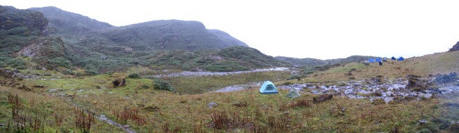
The rain continued incessantly. Pitching and packing up camp was particularly tough. As was the freezing cold – we were unable to make a fire as the wood was too wet.


The main disappointment after climbing so high (up to 4,200m ASL), was that there were no views – it was a complete white out most of the time. So it didn’t matter that we had so much distance to cover and limited time to stop and admire the view … as there was hardly any view to admire anyway!


Miserable weather aside, the lakes that we passed were quite beautiful, and eerie in the mist, reminding me somewhat of Tasmania’s Cradle Mountain National Park.

The icy waters of these lakes and rivers make their way here from the glaciers in the far north of the country. The glaciers of the Himalayas are the 3rd largest area of ice in the world (after the Arctic and Antarctic). These waters continue south into India and Bangladesh. In fact, 40% of the world’s population get half of their drinking water from this source. It truly is a vast pristine wilderness. “The land that time forgot” and “The Last Shangri La” are cliches often associated with Bhutan.
But while Bhutan absorbs more carbon than it produces, it is not immune to the impacts of global climate change. In recent decades these glaciers have been retreating much more rapidly due to global warming. Areas that were once glaciers are now huge glacial lakes and the build up of water pressure on the terminal moraine is increasing the risk of GLOFs (Glacial Lake Outburst Floods). Downstream settlements may have as little as 20 minutes warning to evacuate. Of the 2674 glacial lakes in Bhutan, 24 have been identified by a recent study as candidates for GLOFs in the near future.
So it was heartening to read about the hundreds of thousands of people who took to the streets in the People’s climate march (400,000 in New York City alone), to appeal to world leaders for action on climate change.

…. and meanwhile, there was definitely a sense of personal achievement in finishing this mammoth trek in tough conditions!
